Kenilworth
Walks that start from or go through Kenilworth, with the most recent at the top
Mulled Wine & Mince Pies Walk from Kenilworth
Thanks to Sharron & Pete for leading their festive Mulled Wine & Mince Pies Walk from Abbey Fields Car Park, Kenilworth on Sat 16 Dec. The route of 8.5 miles offers easy walking through the Warwickshire countryside skirting The Warwickshire golf course towards Leek Wootton Church where we stopped for Mulled Wine and Mince Pies! Continuing on, the route passes County Police Headquarters and then heads back towards Kenilworth. The walk is suitable for dogs and there are no stiles.
A Hike from Kenilworth

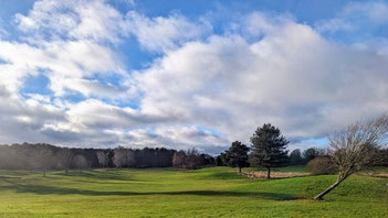
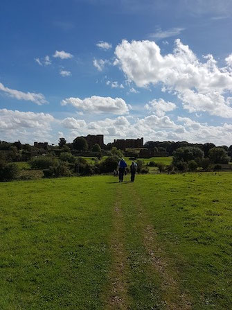
Angus and Tracey Mills led this walk of around 9.8 miles (15.7km) starting from Abbey Fields Car Park in Kenilworth at 9:15am on Sat 12 Aug. There is a van in the car park serving coffee and cakes which is open from around 9am. Many in the group visited The Virgins & Castle, a nearby pub, for post-walk refreshment and lunch.
For parking fees, see the Car Park link above. When we visited it was possible to pay by card or in the RingGo app (location 23851) but not with cash.
A Circular Walk from Meer End to Kenilworth
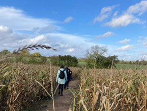
This walk on Sunday 30th October was led by Sue & Bill Kiely from The Tipperary Inn at Meer End. The route includes some lovely woodland, open fields and copses on the Honiley Estate, quiet country lanes, some historic buildings including Honiley Church and Hall, Rudfyn Manor, and of course, Kenilworth Castle.
The walk takes us from Meer End to the edge of Chase Wood, then on to Honiley and Beausale, before reaching Kenilworth Castle. Here we join the Millenium Way on our route back to Meer End, across land formerly part of the hunting grounds of the Castle.
A Walk from Kenilworth
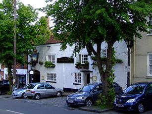
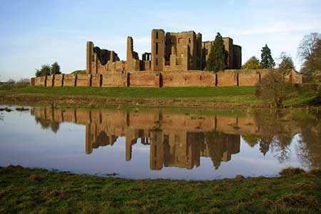
This walk of some 7.7 miles started from Abbey Fields Carpark, Kenilworth, CV8 1BN and was led by Sharron Maguire. The walk started by crossing Abbey Fields to the Castle carpark and thence along Centenary Way, crossing Rouncil Lane and continuing past Goodrest farm to Deer Park Wood. Here it turned right along the bridleway to Bullock Farm and then right again to follow Inchford Brook back to Rouncil Lane. After a short distance along Rouncil Lane the walk followed a footpath back to Kenilworth Castle and from there to the Virgins & Castle for refreshments.
A Hike from Kenilworth led by Bob Reid
This walk will start from the Abbey Fields car park in Kenilworth, CV8 1BP, at 9.00 am., parking is free on Sundays.
The walk is approximately 8 miles long and is mainly across farmland. After crossing Abbey Fields to the castle car park it follows Centenary Way south to Goodrest Farm where it changes to a bridleway in a south westerly direction. At a bridleway cross roads turn right towards Bullock Farm where it turns right again to follow Inchford Brook to Rouncil Lane. After a short distance along Rouncil Lane, back to a footpath across fields to the castle car park and across Abbey Fields to the car park and a well earned drink in The Virgin and Castle.
A Hike led by Sharron Maguire
This walk will be approx. 9.5 miles long and will start at the Tipperary Inn, Meer End, CV8 1PW. Car parking in the pub car park is permissible if stopping for refreshments otherwise there is plenty of roadside parking in Table Oak Lane.
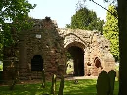
The route leads through mainly flat countryside incorporating an interesting church, pleasant woodland and the delightful Kenilworth castle. The walk incorporates a section of the Millennium Way. The terrain is relatively flat and the route follows a mixture of field and woodland paths.
A Walk from Kenilworth Led by Bob Reid
This walk started from the Abbey Fields carpark in Kenilworth, CV8 1BP. The car park is FOC on Sundays. The walk was approximately 8.5 miles long.
The walk commenced by crossing Abbey Fields to the road leading to the castle car park and turns right down a track just past the castle entrance. Go through a gate on the left to follow a path around the castle on the right to Purlieu Lane. Turn left along Purlieu Lane to a gate on the right way marked Millennium Way, proceed along Millennium Way across several fields to Chase Lane. Turn left on Chase Lane and continue past Chase Wood. Turn left at the end of Chase Wood down a farm track and then right at a way mark, through a hedge over a footbridge and up the a hill with the hedge close on the left, through a gate and turn left to another gate , Go through this gate and maintain direction across the field to a gate onto Church Road. Turn left onto Church Road and proceed past Honiley Hall and follow the road to Beausale keeping left at the screwed T-junction. Shortly past a cross roads with Dirty Lane turn left down Barracks Lane.
A Walk from Warwick University to Abbey Fields in Kenilworth
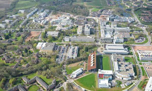
This walk starts from car park 12, Kirby Corner Road, Warwick University, CV4 8UW. On leaving the car park onto Kirby Corner Road turn right and walk along the road towards the university entrance, at the roundabout turn left along Gibbet Hill Road, on reaching the next roundabout turn right and walk through a large group of student lodgings with a lake on the left. At the back of the lodgings keep left and make for Cryfield House, just past this look for a signed footpath on the right and take it. Follow this footpath/cycle track until a narrow footbridge with a distinct uphill angle on the right is reached, cross the footbridge into a field and turn left walking along the edge of the field with a hedge on the close left. Follow the hedge to a gate leading onto a lane, cross the lane and proceed down a footpath/cycle track with frequent cattle grids and bridle gates. At the end of the track, go through a narrow tunnel under a disused railway and follow the footpath to the Coventry Road, on reaching the Coventry Road do a hairpin turn to the left and proceed along a track which leads up to the Greenway, a disused railway.
Loop from Abbey Fields, Kenilworth to Burton Green and back
This walk starts from Abbey Fields Car Park (free on Sundays), Bridge St, Kenilworth, CV8 1BP and is just over 8 1/2 miles. See below for a map and see this album for more photos from the route.
Leave the carpark onto Bridge St. and turn left towards the traffic lights, at the T/L's turn right up New St.. When the main road forks to the left, keep right into Manor Rd., cross to the LHS of Manor Rd. and continue over a bridge past some allotments on the left, then turn left down a cycle track with a hedge between the track and the allotments. At the end of the cycle track turn left into Forge Road opposite The Old Engine public house.
At the end of Forge Rd. take a footbridge on the right over a stream into a wooded area, at a junction of tracks turn right along a cycle track, just before going under a railway bridge turn left through some metal barriers along a cycle track which climbs up. At the top follow the track alongside the railway for a short distance; continue along the track when it leaves the railway and eventually reaches a new footbridge across the main Coventry Road. Go over the footbridge to "The Greenway", a disused railway.
Proceed along the Greenway, and just past the first bridge over it, take a path on the RHS which goes up the embankment back to the top of the bridge. Go through a gate at the top of the path and turn left down a short piece of track to a gate into a field. Follow the footpath along the side of the field with a hedge close on the left into the next field and continue to a road, cross the road through a gate onto a narrow overgrown path.
