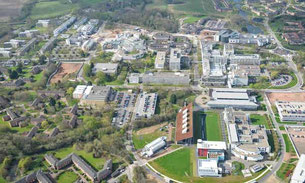
This walk starts from car park 12, Kirby Corner Road, Warwick University, CV4 8UW. On leaving the car park onto Kirby Corner Road turn right and walk along the road towards the university entrance, at the roundabout turn left along Gibbet Hill Road, on reaching the next roundabout turn right and walk through a large group of student lodgings with a lake on the left. At the back of the lodgings keep left and make for Cryfield House, just past this look for a signed footpath on the right and take it. Follow this footpath/cycle track until a narrow footbridge with a distinct uphill angle on the right is reached, cross the footbridge into a field and turn left walking along the edge of the field with a hedge on the close left. Follow the hedge to a gate leading onto a lane, cross the lane and proceed down a footpath/cycle track with frequent cattle grids and bridle gates. At the end of the track, go through a narrow tunnel under a disused railway and follow the footpath to the Coventry Road, on reaching the Coventry Road do a hairpin turn to the left and proceed along a track which leads up to the Greenway, a disused railway.
On reaching the Greenway turn left and continue walking to a bridge. go under the bridge and just past the bridge a narrow footpath on the right leads up to a lane which crosses over the bridge, turn right on the lane and go over the bridge and through a farmyard to reach Crackley Lane. Turn left onto Crackley Lane and follow it until the main Coventry Road is reached, turn right along Coventry Road and walk into Kenilworth. At the cross roads turn left into Bridge Street and cross the road into Abbey Fields car park, walk through the car park into Abbey Fields passing in front of a church, follw the path across Abbey Fields and pass in front of a swimming pool, across a bridge over a stream and continue ahead leaving the park onto Abbey Hill. Turn left along Abbey Hill to the main road, cross the main road and up Rosemary Hill and bear right into Albion Street. Continue along Albion Street to it's end when it crosses Park Road and then into Stoneleigh Rd., after a short distance turn left into Forge Rd. opposite the Engine public house. At the end of Forge Rd. cross a footbridge into a wooded area, just after the bridge turn right along a track and continue until just before a railway bridge, here turn left following the track up a hill. Keep following the track with the railway on the right, eventually this track leads to a bridge over the main Coventry road, go over the bridge back onto the Greenway. Follow the Greenway until a path on the right, signed to Warwick University, is reached, take this path which leads to the footpath/cycle track that was followed earlier in the walk (the narrow tunnel under the disused railway is on the left). Follow the track back to the university, at the edge of the campus do not turn left to follow the route taken earlier but go straight across the road following signs to a milking parlour, which is passed on the left, turn right heading towards the Arts Centre and Students Union buildings, go round the back of the S.U. building and head towards a lake which should be kept on the right. Continue through the campus in front of the Warwick Manufacturing Group building and thence back to Gibbet Hill Road and the car park.


