Angus and Tracey Mills led a Hike on Sat 20 Sep from the Hatton Arms, Birmingham Road, Hatton, Warwickshire, CV35 7JJ (link to the Hatton Arms in Google Maps).
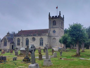
The walk of 9.5 miles (15.2 km) passed through a wide range of landscapes from canal, to housing estate, to rolling Warwickshire farmland, a church yard and a golf course before becoming more urban once again and returning along the canal. The church yard at All Saints' Parish Church, Leek Wootton was an ideal place to stop for a coffee break.
See below for a photo album, a map of the route and a Google Map of the start point.
Click the Learn more button above to open the map in Outdooractive from where you can download the route to the free Outdooractive App for Android or iOS, or export the route to a GPX file for use in other apps.
For more about using Outdooractive, a list of all our routes with GPS files, and a link to folder with all our GPX files including HHIK0142.gpx, the file for this route, see GPS Routes.
