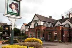
Anna led a hike of 6.6 miles (10.7 km) from The King's Head, Warwick Road, Wellesbourne CV35 9LX (Google Maps) starting at 9:30am on Sun 26 Jan. There is parking in the pub car park but behind the pub is better (follow the one way system and park near the church). The route was almost all on footpaths but had some minor road walking. Many of the fields along this route can have livestock so probably best not to bring dogs.
A view of the start point in Google Maps follows below the photo album and the map of the route.
Click the Learn more button above to open the map in Outdooractive from where you can download the route to the free Outdooractive App for Android or iOS, or export the route to a GPX file for use in other apps.
For more about using Outdooractive, a list of all our routes with GPS files, and a link to folder with all our GPX files including HHIK0128.gpx, the file for this route, see GPS Routes.
