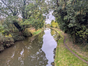
Adrian led a hike of 8.4 miles (13.5km) from the Car Park at Chadwick End Village Hall through varied Warwickshire countryside including a short stretch on the Grand Union Canal towpath.
A map of the route, a link to a GPX file and a view of the start point in Google Maps follow below the photo album.
Click the Learn more button above to open the map in Outdooractive from where you can download the route to the free Outdooractive App for Android or iOS, or export the route to a GPX file for use in other apps.
For more about using Outdooractive, a list of all our routes with GPS files, and a link to folder with all our GPX files including HHIK0120.gpx, the file for this route, see GPS Routes.
Coming into Chadwick End on the main road from Knowle, the Village Hall is on the left just before The Orange Tree pub on the right. The Car Park is on the Knowle side of the Village Hall and there is quite a tight turn-in through the security gate.
