There will be a hike starting from the Hatton Arms,CV35 7JJ, starting at 9.30 am.
This is a shorter variant of the Hatton Walk that we have done previously, approximately 9 miles long. Easy walking mainly on bridleways, pavements, metalled tracks / minor roads and good canal towpaths with minimal mud: a banker for this time of year.
A route description follows; for a map and a link to a GPX file for the route, please see the bottom of this page.
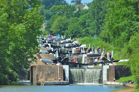
Exit the pub car park onto the pavement alongside the Birmingham Road A4177, turning right (towards Warwick). Pass in front of the pub to a footpath on the right; take the footpath and walk downhill to the canal. At the canal turn left (towards Warwick) passing the dragonfly sculpture and the series of lock gates. Continue along the canal to bridge 53; exit here onto Middle Lock Lane and to the A4177.
Cross the A4177, turn right then almost immediately left and continue ahead on the same bearing as before along an obvious footpath; cross Barcheston Drive and continue uphill through Hatton Park following the path ahead until it arrives at Barcheston Drive once more. Across the road and slightly to the right is a footpath continuing in the same general direction; take this path and continue along it for a couple of hundred yards; as the footpath turns to the left look for a turn on the right; leave the main path at this point (i.e. turn right) and follow this meandering path to Wedgnock Park Farm at which point the path becomes a metalled track. Just before reaching the farm buildings the path turns right and continues ahead before reaching the A4177 once more.
Cross the A4177 and walk along Old Budbrooke Road towards Warwick Parkway Train Station. The road crosses the canal and forks; take the left fork reaching the canal via a car park. Cross the canal at this point by walking over one of the lock gates and, having done so, turn right and continue along the canal towards Warwick.
Leave the canal after passing under bridge 50, walk along Cape Road and turn right onto Wedgnock Lane. Continue along Wedgnock Lane looking for an opportunity to cross the road. Ahead is a bend in the road at which point a ‘spur’ road (also called Wedgnock Lane) leaves the main road (Outdoor Activity Centre signposted).
Take this more minor road and continue ahead for approx. 2 miles before reaching Bulloak Farm. Pass through the farm continuing along the main bridleway (ignoring the footpath on the right) to a minor road (Kites Nest Lane). Turn left here and, after half a mile or so, turn left again at the next road junction onto Brownley Green Lane. After a few hundred yards turn right leaving the road at a 5 bar metal gate and take the footpath along the track, bearing left towards Home Farm. Just before reaching the farm buildings the path exits the track via a gate on the left passing through a copse before skirting around the farm buildings and onto the driveway to the farm.
Once on the driveway look for a path on the right (easily missed); leave the driveway at this point and continue on a diagonal across a field of crops to an old metal gate; pass through the gate across a driveway to another metal gate and continue across another field of crops to the A4177 and Holy Trinity Church.
Cross the road and pass through the churchyard continuing along an obvious path towards some houses in a cul-de-sac (Starmer Place). Continue along the cul-de-sac to a T junction (The Green), turn left and continue ahead to a crossroads with the Hockley Road (B4439); continue straight ahead along Dark Lane towards the entrance to Hatton Country World. After quarter of a mile or so the road crosses the canal and there is a path on the right which leads to the towpath. Join the canal at this point; turn right, under the bridge and walk along the towpath in the direction of Warwick. Pass the Hatton Locks Café the Hatton Arms is clearly visible from here on the top of the hill on the opposite side of the canal. Continue to a canal bridge, cross the bridge and head to the left and uphill back to the pub.
Spoils of the shoot! (Home Farm, Hatton, 13 Jan 2019. Photo by Evan Grant)
Click the Learn more button above to open the map in Outdooractive from where you can download the route to the free Outdooractive app for Android or iOS, or export the route to a GPX file for use in other apps. A GPX file for this route can also be downloaded from here. For more about using Outdooractive, and a list of all our routes with GPS files, see: GPS Routes
