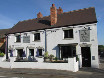
This walk will start from The Malt Shovel, 39, Grange Rd., Hartshill, CV10-0SS. at 9.00 am. and is approximately 9.5 miles.
Parking: Please avoid parking in the pub car park which is quite small; limited street parking is available in Grange Road; there is also a lay-by a little way along the road (after passing the pub) next to a small park on the left.
The walk is a varied mix of disused quarries, pretty countryside, urban streets, canal towpaths, a golf course and a country park with a woodland walk finishing off at a recently rebuilt pub (after a fire that gutted the place) with 4 hand-pulled ales and a great selection of well-priced food and very generous portion sizes.
Walk Description
Grange Road is part of the Quarryman’s Walk which the route follows for the first part of the walk, heading away from the village towards the railway line. There is a small park on the left and a carved stone just after the park; at this point the Quarryman’s Walk leaves the road to the right arriving at the canal towpath where the path continues to the right along the canal and to a road; cross the road (near the Anchor Inn) and continue along the canal towpath for a short distance before taking a left turn. Follow the path ahead turning right to follow the railway line to a concealed bridge; cross the railway line at this point. Shortly after crossing the railway line the path forks which is where we leave the Quarryman’s Walk taking the path straight ahead across a field to a track; turn left along this track and continue ahead until reaching a minor road; turn right following the road, crossing the river Anker and passing some houses and a Care Home before taking a path on the left. Continue along this path until reaching a busy road; turn left and after 100 yards or so cross the road and take path on the right. Continue ahead, following the path in the direction of Mancetter. Just before the path converges with the A5 there is a turn on the left passing through an old Roman settlement (there are no obvious structures remaining, however, the surrounding fields are littered with pieces of Roman pottery). Continue ahead crossing the river Anker once more before reaching the Nuneaton Road; cross the road at this point and continue ahead along Quarry Lane (a bit of care is needed along this section of road which is fairly minor but seems to be quite a popular route). After half mile or so there is a bridge over the canal and an entrance onto the canal on the left; join the canal here, passing (right) under the canal bridge and walking along the tow path. After 800 yards or so a bridge crossing of the railway joins the path from the right shortly before a bridge crossing the canal; continue along the canal to the next bridge, exiting the canal at this point and crossing the bridge. The path continues ahead through Atherstone Golf Course, passing the Club House and continuing ahead keeping to the left of a hedge before passing back through the hedge and a few hundred yards later and continuing the same direction of travel following the hedge line along a well-trodden path. After several hundred yards the hedge turns left and ahead of you across the fairway is the entrance to the path which runs to the right of some houses and farm buildings and continues to a road. Turn left along the road walking 200 hundred yards or so before taking the second foot path on the left. The path cross the golf course once again, heading downhill to footbridge over a stream and then continuing ahead up a fairly steep hill. Keep the farm buildings on your right and after passing the farm buildings head for the right hand corner of the field to join a track continuing in the same direction to a road. Cross the road and continue through a (plant) nursery keeping to the left, continuing ahead and passing to the left of some small ponds. At this point a huge, man-made mound comes into view; happily the path has been diverted around this mound. Follow the path ahead in the same general direction until reaching a road. Turn left here and walk past another Care Home before entering Hartshill Hayes Country Park for some stunning views of the surrounding area. Head right from the viewing point walking downhill on a diagonal towards the entrance to a wooded area; there are two paths at this point: one that skirts the outside of the wooded area and the other that passes through the woods; both paths lead to the same point so both are options; the walk through the woods is the shorter and more charming route. If continuing through the woods the path continues ahead until reaching a carved stone at which point there is a clearly marked left turn. The path continues ahead from this point to some boards crossing a boggy area and up a flight of steps to Trentham Road. Turn right at this point and look for the Stag and Pheasant Inn on the left. Cross the road passing in front of the Stag and Pheasant Inn to Grange Road and back to the Malt Shovel for a well-earned drink, passing yet another Care Home.
