This walk starts at the Bulls Head in Furnace End, B46-2LG and is approx. 9.5 miles long.
Something for everyone: an old Colliery, rolling Warwickshire countryside, a path through Arley Wood, quiet country lanes a coffee/toilet stop and one of the best pubs around with great atmosphere, ales and food.
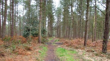
The walk starts by crossing the road from the car park (heading right) before turning left off the road along a clearly marked footpath which follows course of the railway line passing Daw Mill Colliery (surprisingly walking along an old and now disused portion of the railway that was in use when Daw Mill was a working Colliery). The path goes under the railway line to a road; turn left here and walk a short distance looking for a footpath on the right; take this path, following a course straight ahead remaining parallel with the railway line and crossing an open field to a hedge line opposite (signage is not great but keep the faith). The path bears to the right and heads uphill away from the railway line towards a road; shortly before reaching the road there is a metal gate on the left; at this point make a hairpin turn to the left back towards the railway line and another metal gate; pass through the metal gate and under the railway line once more. Signage is again poor at this point but trust the map and head straight and slightly to the left to another metal gate by a telegraph pole. Some farm buildings come into view; keep these buildings on your left and head towards two metal gates behind the farm buildings which lead to a road. Cross the road heading slightly right to metal gate; pass through the gate and continue straight and bearing very slightly to the left; again trust the map and keep the faith as signage is poor. Upon arriving at the road, turn left and walk downhill a few hundred yards looking for a path on the right; turn right here; continuing along this path you will see a clearly marked metal gate over to the right; head for this gate. At this point ignore the temptation and signage to continue ahead and, instead, turn right following the hedge line uphill. White House Farm comes into view (ahead and right); keep the farm on your right and open fields on your left and continue straight; upon passing the farm head slightly right on diagonal towards the corner of the field passing a large bungalow and arriving at a metal gate. Pass through the metal gate and turn immediately left walking along Wood Lane on the edge of Arley Wood; after quarter of a mile or so there is an unmarked entrance into the wood and a path leading into the wood heart of the wood. At this point there is also a path running parallel to the Wood Lane which is an alternative to continuing to walk up Wood Lane; continue to follow Wood Lane (either on the road or on the path in the woods). After a further quarter of a mile there is a broad track heading right into the woods (entrance from Wood Lane is via a large, green metal gate). Take this track into the wood; a short way down the track there is a fork in the track; take the right hand fork and continue down the track, eventually exiting the wood; at this point there are some farm buildings to the right and, to the left, a clearly marked metal gate; head left walking alongside the wood and passing through the metal gate and into a field; head for the far right hand corner of the field where there is a another metal gate; pass through the metal gate and turn immediately left crossing a small wooden bridge. Continue straight keeping the wood on your left. Upon arriving at the edge of the wood there is a choice of routes; head straight ahead across the open field at this point to a road (Mill Lane). Turn left along this quiet country lane walking a distance of around a mile to the Nuneaton Road, crossing straight over and heading down the drive to Hoar Park Farm where there are toilets and a café; this is around the 6 mile mark which is an ideal time for a short break. Head away from the café/toilets to the car park and notice the footpath sign immediately ahead. Take this path which turns immediately right and heads down hill towards a bridge over a stream; signage points across an open field; though the precise route is not clear there is a metal gate in the hedge opposite. Upon passing through the gate turn immediately left picking up Centenary Way. For a major trail signage along this section is very poor so, yet again, keep the faith and trust the map. After a short distance there is a hedge boundary; as indicated on the map keep the hedge on your right and continue straight for quarter of a mile to an open field; at this point signage is poor, once more. Uphill to the right is Holt Hall Farm, downhill is a stream; the route heads straight and slightly away from the farm buildings and towards the stream across the open field arriving at a style that is concealed until you are almost on top of it. Cross the style and enter a field which slopes steeply to the left; take the high route at this point and do not be tempted to descend the hill as the exit from this field is at the top of the hill. Upon exiting the field, head left down the hill to a cow shed and another farm (Hoar Hall), passing through the farmyard and crossing a small bridge at which point bear right through a field to a metal gate on the opposite side of the field. Continue straight keeping some fishing pools on your right until reaching a tiny house and a quiet road. Turn left along the road and almost immediately right crossing a field to a metal gate and then passing along a footpath to a road (the B4114). Cross over the road and head downhill (right) 100 yards or so to Furnace End crossroads; turn left at the crossroads and the Bull comes into view. On you left is the renowned Robert Tuckey’s Butchers which is well work a visit.
