This walk begins at the Navigation Inn at Lapworth, B94 6NA and is approximately 9 miles long. The route is chosen to avoid crop fields and muddy towpaths as far as possible, and the walk leader when we walked this route on 14 Jan 2018 was Angus Mills.
A map of the route and a link to a GPX file follow below the route description and the photos.
Head South along the canal following ‘The Arm’ to Kingswood Junction moorings. Cross the bridge next to the moorings and leave the canal at this point walking through the car park opposite and onto ‘Brome Hall Lane’; this is the only section of canal on the walk. Upon exiting the car park turn left down a track, skirting round ‘Brome Hall Farm’. Continue ahead passing under the M40 eventually reaching a road near a large brick house called ‘High Chimneys’. Turn left walking a short distance along the road to a junction on the right; turn right here into ‘Broomfield Lane’.
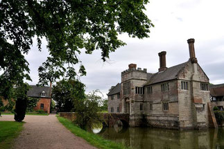
Continue down ‘Broomfield Lane’ ignoring the bridleway sign on the left and continuing to a sharp bend in the road leaving the road at this point via a footpath on the left. Continue on the footpath which runs alongside ‘Bush Wood’ passing ‘Coppice Corner Farm’, crossing a dismantled railway and continuing to a minor road. Turn left along the road walking a short distance to a footpath on the left; head along this path to the point that it meets the ‘Heart of England Way’. Continue straight over a style along the ‘Heart of England Way’ towards Lowsonford. Upon reaching a crossroads in Lowsonford continue straight ahead along the ‘Heart of England Way’; this part of the walk is a fairly long stretch of road which eventually reaches a bridge that crosses the M40. Immediately after crossing the bridge turn right down a track which runs alongside the motorway for a short distance before turning left towards the Grand Union Canal. Cross the canal at Rowington Hill Bridge and head towards Rowington arriving at St Lawrence Church. Pass through the churchyard exiting on the left and continuing along the ‘Heart of England Way’ towards Baddesley Clinton. Upon reaching a road cross over and up the driveway of ‘Green Farm’ heading through the farmyard before bearing right towards ‘Hayward Lane’. Turn left walking along ‘Hayward Lane’ for some distance. On the left there is a clearly marked route to ‘Baddesley Clinton’ along a wide track; there is also a metal gate with a footpath sign; take the wide track passing through St Michael’s churchyard, past ‘The House’ at Baddesley Clinton and heading right along the drive away from the house. A short distance along the drive turn left following the ‘Heart of England Way’ (partway along the route there is a right turn along a path marked with carved animals; ignore this turn and instead continue straight keeping closer to the house). Upon reaching ‘Old Warwick Road’ turn right to return to the Navigation Inn.
Photos by Mary Coles from the walk led by Angus & Tracey Mills on 14 Jan, 2018.
Photos by Tracey Mills from the "recce" walk on 6 Jan, 2018.
Click the Learn more button above to open the map in Outdooractive from where you can download the route to the free Outdooractive app for Android or iOS, or export the route to a GPX file for use in other apps. A GPX file for this route can also be downloaded from here. For more about using Outdooractive, and a list of all our routes with GPS files, see: GPS Routes
