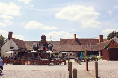
This walk of approx 7 miles / 11 km was led by Kay Dick from the car park of the Fleur de Lys, Lowsonford (B95 5HJ). Walk directions:
From the pub car park turn right down the road to a telephone box and there take the footpath on the left and follow the Heart of England Way through a field on the right over a stile, cross two fields and then over a stile into a lane, turn right. After a short distance turn left through a double kissing gate and proceed along the edge of a field with the hedge close on the left to a wood, follow the HoE way through the wood.
On emerging from the wood follow the path for a short distance then go through a gate on the left and continue following the HoE way to a gate onto a hard track, turn left along the track, over a dismantled railway bridge to a road. Turn right on the road around a left hand bend and then take a footpath on the right, still HoE way, past Holly Bank Farm. Keep following HoE waymarks until Edge Lane is reached, turn right up Edge Lane through the trees, leaving the HoE way, and then go over a stile on the left into a field, Millennium Way, down a steep hill, crossing diagonally across the field, at the bottom turn half left and go across a field to a footbridge by Buckleys Farm.
After the footbridge turn right along a lane and shortly after the lane joins a road look for gate on the right into a field with a Millennium Way waymark, go through the gate. Follow the path across fields up a steepish hill by Irelands Farm keeping to the left at the entrance to the farmyard, through a hedge onto a farm track. Turn left on the track and then turn right onto Irelands Lane at Hill Barn Farm.
Proceed along Irelands Lane for approximately 1 mile to cross roads, go straight across the cross roads to Copt Green, after about 100 yards take a footpath on the right, leaving the Millennium way, crossing a field to a road. At the road turn left following the road through a wooded area and when the road turns sharply to the right take a footpath on the left and follow the path along the field edge with a hedge on the left, shortly after passing under electric cables go through the hedge and maintain direction with the hedge on the right to a road.
Turn left on the road passing High Chimneys and then take the footpath on the right with a yellow marker. Cross the field to the canal, turn right along the towpath to bridge 41 and then leave the canal, cross the bridge and turn right back to the Fleur de Lys. (For a slightly shorter variant of this route, please see the bottom of this page.)
Click the Learn more button above to open the map in Outdooractive from where you can download the route to the free Outdooractive App for Android or iOS, or export the route to a GPX file for use in other apps.
For more about using Outdooractive, a list of all our routes with GPS files, and a link to folder with all our GPX files including HHIK0016.gpx, the file for this route, see GPS Routes.
At just under 6 miles, the version of the route shown below is about 1 mile shorter than the route above as it misses the final section down to the canal and back along the towpath. In the final paragraph of the original directions above, where it says "Turn left on the road passing High Chimneys ...." instead turn right and follow the road (Lapworth Street) to Lowsonford, through the village and back to the Fleur de Lys. For a GPX file of this shorter route, please click here.

Map Copyright Thunderforest - Data Copyright OpenStreetMap contributors
