This walk starts from The Bulls Head at Barston. There is a car park at the pub , post code is B92 0JU or you can park in the church car park. The walk is around 8-9 miles.
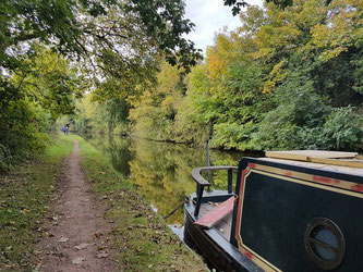
Starting from The Bull, turn left along the road until you come to St Swithin's Church. Which will be on your right. Go through the church gate and walk to the far right corner where you will find the footpath. Then take the next gate on the right following along the side of the fence. Then going through the next gates past the Alpaca's and sheep in their small paddocks. Through two fields until you come to the road. Cross the road where you will find two footpaths, take the footpath on your left. Take the foot bridge across the river. Walking through two fields until you get to Nappins Covert. Take the footpath towards Knowle across the fields until you get to the Canal. Turn left taking the canal path, passing by Knowle Locks, The King's Arms until you get to The Black Boy pub on your left.
Following the green beer garden fence to it end where you will see a footpath sign. Now leave the canal path go through the pub car park down the drive to the main road. Turn left along the road until you come to the bend. Cross the road taking the footpath until you come out in a yard. Keep following the path cross a small brook and up a old farm track until you get to the road. Turn right along the road until you get too a fork in the road. Take the footpath on your left, through 3 fields until you get to Temple farm. Go down the farm lane until you get to the road. Turn right until you see a footpath sigh on your left. Go through two fields where you will come to 3 footpath signs. Take the path on the left. (Heading towards Barston). Across fields, and over the footbridge at the river Blythe. Walking across three fields until you come back to St Swithin's Church. Go through the church yard to the road. Turn left walking to The Bulls Head pub.

Click the Learn more button above to open the map in Outdooractive from where you can download the route to the free Outdooractive App for Android or iOS, or export the route to a GPX file for use in other apps.
For more about using Outdooractive, a list of all our routes with GPS files, and a link to folder with all our GPX files including HHIK0006.gpx, the file for this route, see GPS Routes.
