This walk starts from Abbey Fields Car Park (free on Sundays), Bridge St, Kenilworth, CV8 1BP and is just over 8 1/2 miles. See below for a map and more photos from the route.
Leave the carpark onto Bridge St. and turn left towards the traffic lights, at the T/L's turn right up New St.. When the main road forks to the left, keep right into Manor Rd., cross to the LHS of Manor Rd. and continue over a bridge past some allotments on the left, then turn left down a cycle track with a hedge between the track and the allotments. At the end of the cycle track turn left into Forge Road opposite The Old Engine public house.
At the end of Forge Rd. take a footbridge on the right over a stream into a wooded area, at a junction of tracks turn right along a cycle track, just before going under a railway bridge turn left through some metal barriers along a cycle track which climbs up. At the top follow the track alongside the railway for a short distance; continue along the track when it leaves the railway and eventually reaches a new footbridge across the main Coventry Road. Go over the footbridge to "The Greenway", a disused railway.
Proceed along the Greenway, and just past the first bridge over it, take a path on the RHS which goes up the embankment back to the top of the bridge. Go through a gate at the top of the path and turn left down a short piece of track to a gate into a field. Follow the footpath along the side of the field with a hedge close on the left into the next field and continue to a road, cross the road through a gate onto a narrow overgrown path.
Continue along this path to a junction of farm tracks, at this point look for a farm gate on the left leading to a footpath with the hedge on the left, take this path. Follow the path to a gate leading to Crackley Lane. Turn right onto Crackley Lane for about 3/4 mile until the road turns sharply to the right, here maintain direction through a gate into a field and continue with a hedge on the right. About halfway along the field turn half left towards a walk post in the centre of the field, go past the post to the left corner of the field. Go into the next field with a wood on the right and follow the path to a set of steps going up to the Greenway, cross straight over the Greenway and down more steps into a field with a hedge on the right. Follow the path to a road.
At the road turn right to a T-junction and then turn left along Hob Lane. Walk along Hob Lane for about 0.6 mile to Moat Farm and then go left over a footbridge to a gate into a field, go ahead across the field with two beautiful old half timbered buildings on the left into the next field and then turn half right to wards a gate in the hedge. Go through the gate and maintain direction over the next field passing under overhead cables to a gate hidden in the hedge leading to a path with a hedge close on the left. Follow the path past farm buildings to the left to a gate leading to a farm track. Cross over the track and through a hedge leading to the Millennium Way, go half left and diagonally across the next two fields, over a style, and then half right and diagonally across to the far left corner and then turn left towards some trees. Through the trees to a style leading onto the main A452 road.
Cross the road and maintain direction across a cultivated field, through a hedge and then turn left following the Millennium Way signs keeping the hedge on the left. At the end of the field go through two gates into another field, here go half right and diagonally across the field to the far right corner, here, go through the hedge by crossing two styles and then turn left to the corner of the field where the path turns right. Follow this path with a hedge on the left to the end of the field and there go through a gap in the hedge and turn right, now with the hedge on the right to the corner of the field, go round the corner following the hedge. Maintain direction past a gap in the hedge to where the hedge turns right, here follow the waymark signs for the Millennium Way and maintain direction across the middle of a cultivated field to a farm drive, turn right along the drive towards Rudfyn Manor. Just before reaching the manor turn left following Millennium Way signs through some trees and then turn right along the edge of a field keeping a hedge on the right. At the end of the hedge go half left across a cultivated field, at the other side turn left with a wooded area on the right and then follow the path round to the right and then left and when reaching a hedge turn right with the hedge on the left. Continue following Millennium Way signs keeping the hedges on the left and after passing under some overhead cables on pylons but before reaching overhead cables on wooden poles look for a path across the middle of a cultivated field and take it (the waymark is hidden in an overgrown hedge).
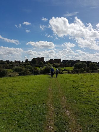
Maintain direction and continue following Millennium Way signs across another cultivated field and through a copse turning right on emerging and keeping the hedge on the right. Continue to a gate leading to Chase Lane which is crossed into a cultivated field where Kenilworth Castle can be seen in the distance. Proceed across the middle of this field, through a hedge, turn left to a field corner through a gate and some trees and then turn half right across the middle of another large cultivated field, through another gate and then across yet another cultivated field. At the end of this field follow the path right and left then across a pasture with Kenilworth Castle now very close ahead; keep to the path until a gate onto a lane to the castle is reached. Turn left on the lane and walk past the castle on the right to the main road, here cross the road and turn right past The Queen and Castle and then up Castle Hill into High St. Just before reaching the traffic lights the Virgins and Castle public house is passed on the right which is ideal for some refreshment before getting back to the carpark, for which turn right at the T/L's onto Bridge St.

Click the Learn more button above to open the map in Outdooractive from where you can download the route to the free Outdooractive App for Android or iOS, or export the route to a GPX file for use in other apps.
For more about using Outdooractive, a list of all our routes with GPS files, and a link to folder with all our GPX files including HHIK0004.gpx, the file for this route, see GPS Routes.
